App Store
 Google Play

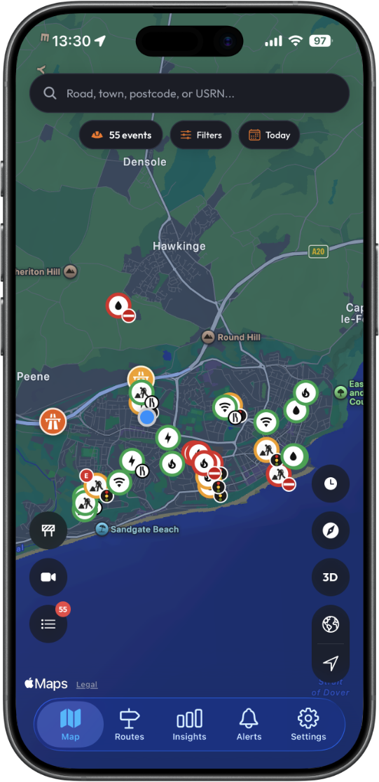
 Explore the Map


DfT Street Manager
Every UK permit — live within 2 minutes via SNS push across all counties and unitary authorities.
Live
Real-time permit data from every major UK source — Street Manager, National Highways, TfL, and Traffic Scotland — delivered to your phone within 2 minutes.
Street Manager
Live within 2 min
Every year, millions of roadworks permits are granted across the UK. Yet historically, this data has been scattered across dozens of local authority systems — impossible to search and hours behind reality. For commuters, fleet managers, and highways professionals, that fragmentation means wasted journeys and decisions made on stale information.
Roadworks Trackr fixes that as the UK's first dedicated roadworks application. We aggregate live feeds from major official networks — including DfT Street Manager, National Highways, Transport for London, and Traffic Scotland — delivering a single, searchable map updated within 2 minutes of a change.
Free to download. No account required to start exploring.
App launched
Official data sources
Core features, always
Free users (with or without an account) get a 5-mile radius view based on current location, 3 location searches per day, and up to 5 taps on individual works per day.
Historical permit data
Notification to app
Live data sources
Permits processed
incl. 3yrs archive data
VMS signs tracked
Traffic cameras
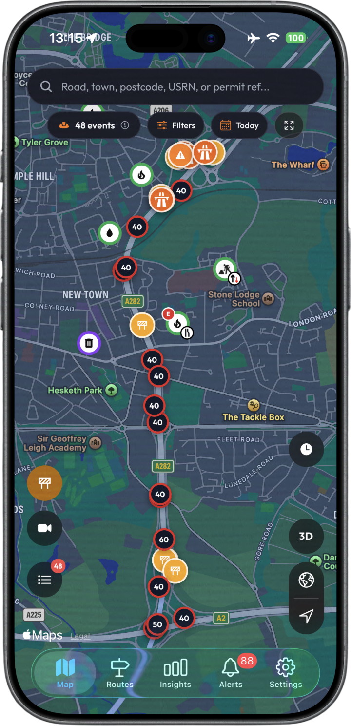
A rich, interactive map with a powerful filter panel. Filter by permit status, work category, promoter, and traffic sensitivity — then toggle on TfL cameras, VMS signs, and National Highways live closures.
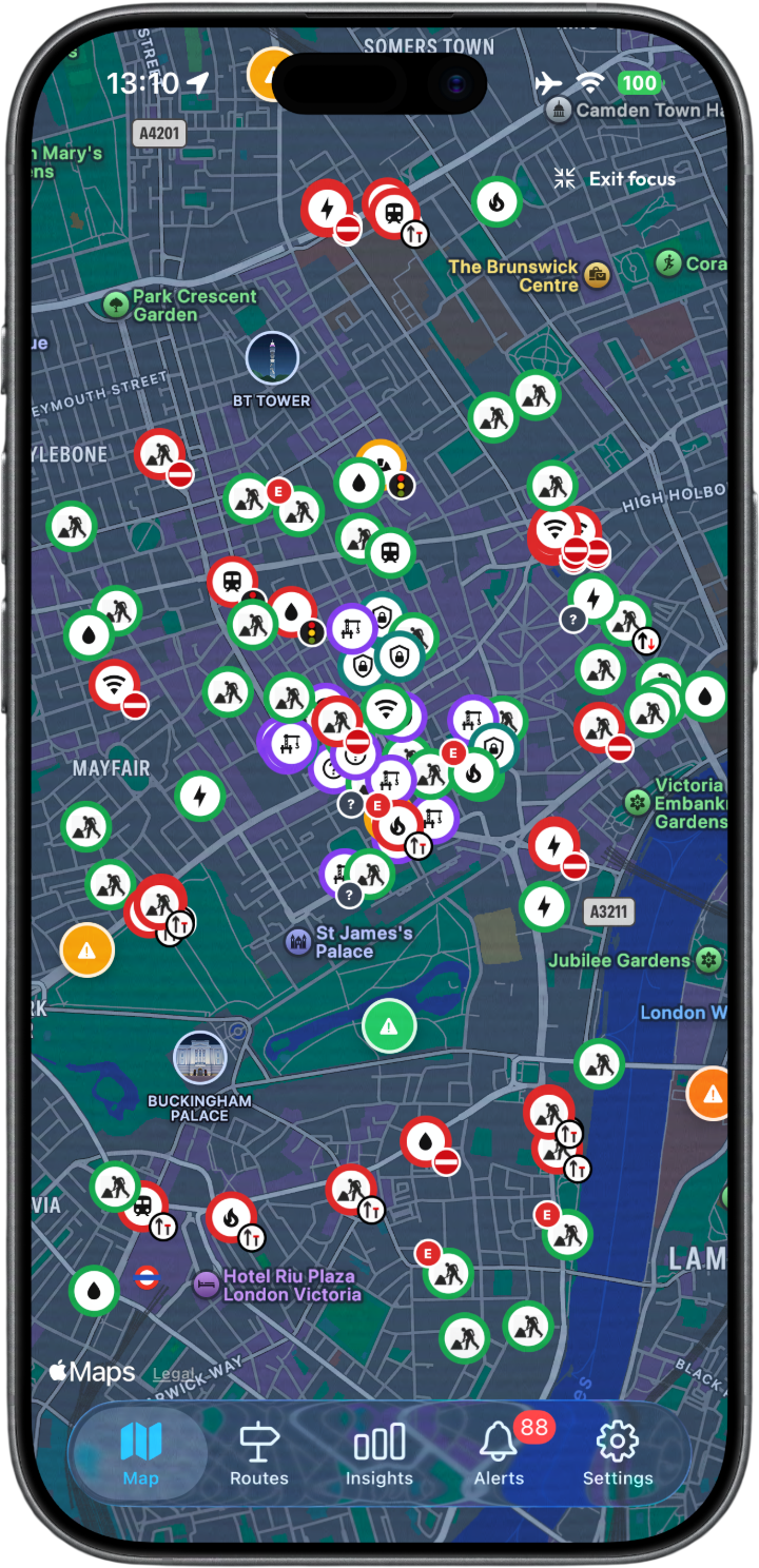
Map view of London showing Roadworks, Activities and TfL Incidents
Ireland, Northern Ireland & Wales not currently covered
TfL JamCam Feed
NH Managed Speed Areas
NH Traffic Camera
A clean, fast app built for anyone who needs to stay ahead of roadworks — from daily commuters to fleet managers to highways professionals.
Free to download · No account required to browse the map
"I commute into London every day and the roadworks on my route change constantly. This app has genuinely changed how I plan my morning. I check it before I even get in the car. The camera feeds are a brilliant extra."
"Really impressed with how quickly new permits appear on the map. I had one show up within minutes of it being granted. The detail you get on each permit, promoter, dates, conditions, is more than I expected from a free app."
"Finally an app that shows National Highways closures alongside street works on the same map. I used to have to check three different websites. This does it all in one place and the push notifications actually work."
"Wasn't sure how useful it would actually be but I've been using it every morning for about three months now. It's saved me from sitting in a big delay on the A406 twice already. The alerts are spot on."
"Been on the Pro plan since launch and it's worth every penny. The journey checker is the bit I use the most. Planning a long drive and being able to see every set of roadworks along the route before you set off is something no other app does."
"I'm out driving most of the day for work and this has become as essential as Google Maps to me. The live map updates fast and the filters mean I can narrow it down to just what's relevant to where I'm working that day."
From free live permit data to Ultimate-tier diversion routes and professional analytics — there's a plan for every level of need.
Every UK Street Manager permit — live within 2 minutes across all counties.
Motorway closures, A-road incidents, and DATEX II events on the map.
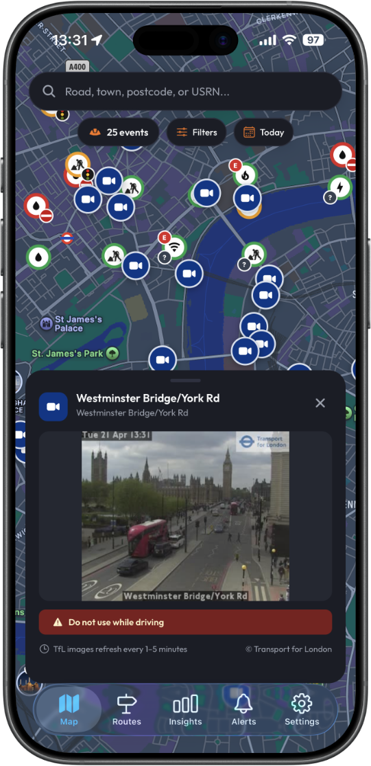
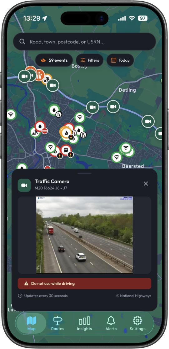
Live NH camera feeds and TfL JamCams — tap any pin to see the live image.
Promoter, highway authority, traffic management, dates, permit reference and NCT conditions.
Search any street or area for the full 3-year permit history.
Save named routes and get a live disruption score for every road on them.
Permit timelines, disruption scores, and activity by street or county.
Custom alerts by location, radius and work type — delivered as push or email digest.
When NH closes a motorway, the official signed diversion is overlaid on your map automatically.
Overrun rates and permit histories by utility company and highway authority.
Search by Unique Street Reference Number for precise street-level data.
Set up automated email notifications to stay informed about roadworks in your area or along your daily commute. Immediate and Emergency works trigger an instant email — daily and weekly digest summaries also available.
Plan a route and instantly see every roadwork and closure that falls on your path — for car or HGV.
A live roadworks co-pilot built to run alongside your existing navigation app. A heading-up GPS map follows your position, and automatic proximity alerts warn you about works ahead — showing promoter, works type, traffic control, and end date. Configurable alert distance. Designed to complement Google Maps, Apple Maps, or Waze — not replace them.
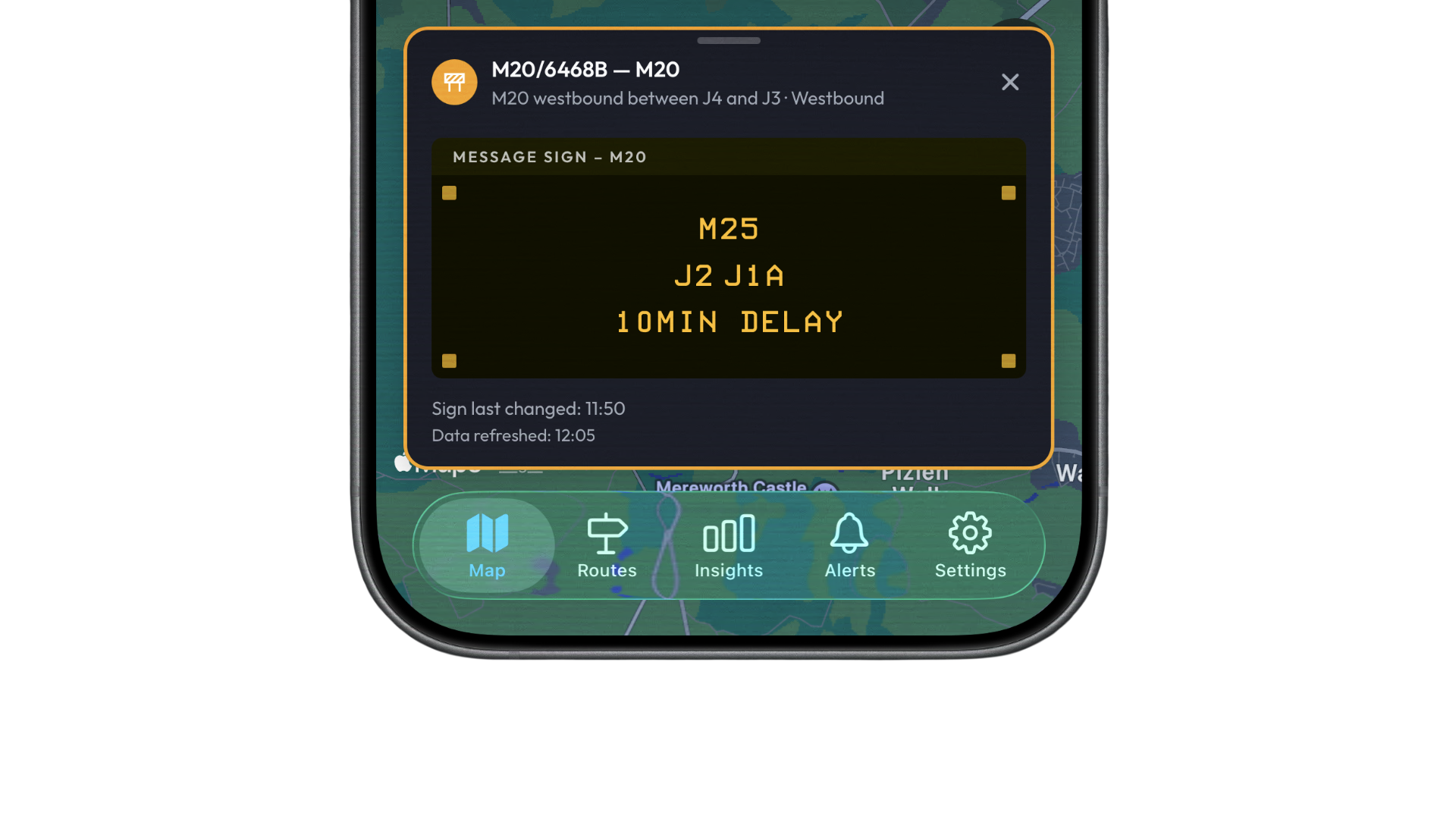
Live gantry and roadside VMS from National Highways and Traffic Scotland — see current messages directly on the map.
Filter by work category, utility type, promoter, permit status, and traffic management type to cut through the noise.
Step-by-step permit history from application to closure, plus a full amendment log for every change made.
Tap "Report a Problem" on any permit to open the relevant highway authority's reporting page — or long-press on the map to load it automatically for that location.
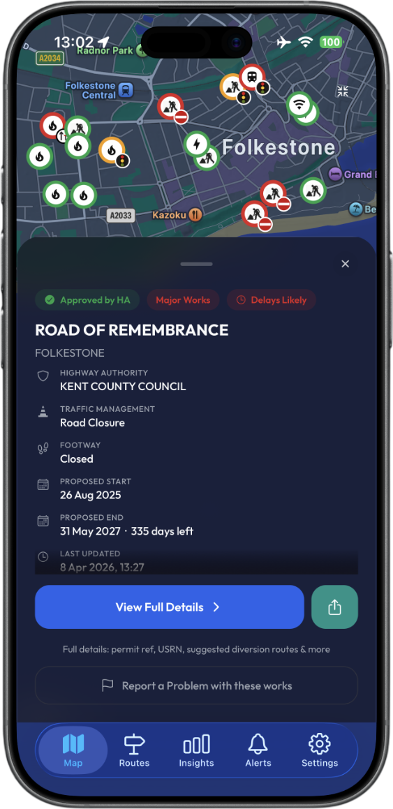
Everything on a permit — for free.
Driving Mode is a live roadworks co-pilot — not a navigation app. A heading-up GPS map follows your position as you drive, and automatic proximity alerts fire when roadworks are detected ahead, showing the promoter, works type, traffic control type, and expected end date. Alert distance is configurable. It is designed to run alongside Google Maps, Apple Maps, or Waze, giving you full roadworks awareness without switching apps. Available now for Ultimate subscribers only.
⚠️ Driving Mode is a situational awareness tool. Always use a dedicated navigation app for routing and follow official signed diversions when in place.
Dedicated portal for highway authorities — view all works in your area, filter by promoter and permit status, and export data at your personalised URL.
Get started free. Upgrade for historical data, route monitoring, insights and professional tools.
Browse live roadworks near you — free, within a 5-mile radius of your current location.
Full UK map coverage, VMS signs, route monitoring, and push & email alerts.
Full professional-grade intelligence for power users & teams.
Custom licensing for councils, highway authorities, utility companies, and large organisations. Every seat includes full Ultimate-tier access. Invoiced directly — no App Store payment required.
| Seats | Price / year | Per user / mo |
|---|---|---|
| Up to 25 | £1,399 | £4.66 |
| Up to 50 | £2,499 | £4.17 |
| Up to 125 | £4,999 | £3.33 |
| Up to 250 | £8,999 | £3.00 |
| Unlimited | Contact Us | Custom |
All prices ex-VAT. Per user / mo figures are indicative based on annual price ÷ seats ÷ 12.
Talk to Us →A dedicated analytics portal for highway authorities — your own secure, authority-branded dashboard, refreshed every 5 minutes. Built for NRSWA compliance, monthly board reporting, and network-wide management oversight. Every permit, every promoter, every overrun — in one place.
Live permit data pulled from Street Manager and National Highways every 5 minutes. Your dashboard always reflects the current state of the network — no manual imports, no stale spreadsheets.
Visual works-density maps across your entire network, filterable by permit category, Traffic Management type, and promoter. Instantly identify pressure points, recurring hotspot streets, and where to direct inspection resource.
Compare utility performance across 11 columns — overrun rates, average overrun days, road & footway closures, collaborative working, cancellations, and average grant times. Know exactly which promoters are causing the most disruption.
High-fidelity PDF reports and CSV exports for board packs, legal notices, and inspection records — covering permit volumes, overrun summaries, S58 contravention logs, and USRN hotspot data, formatted for immediate use.
Top 20 most disrupted streets ranked by permit volume, road closures, overrun counts, and S58 activity — filterable by date range. Includes interactive heat maps showing works density across the entire network.
Time-series charts of permits, closures, overruns, collaborative working, and grant speed across a rolling 3-year window. Spot seasonal patterns, measure year-on-year improvement, and demonstrate compliance progress to stakeholders.
Metrics tracked
Requires an active Enterprise or Council licence. Each authority receives a secure, personalised dashboard URL. Multi-user access included. All prices ex-VAT.
Enquire about the Suite →Roadworks Trackr is the UK's first dedicated roadworks intelligence app for iPhone and Android. It brings together live data from DfT Street Manager, National Highways, TfL, Traffic Scotland, and Scotland Roadworks (SRWR) onto a single interactive map — updated within 2 minutes of any change. You can filter by work type, promoter, and status, and explore permit details across the network. Ireland, Northern Ireland, and Wales are not currently covered. Upgrade to Pro or Ultimate to unlock alerts, route monitoring, advanced filters, and in-depth Insights.
Yes — the core app is completely free to download, with or without an account. Free users get a 5-mile radius view based on their current location, 3 location searches per day, and up to 5 taps on individual works per day. Pro and Ultimate subscriptions remove these limits and unlock route monitoring, push notifications, email alerts, advanced filters, Journey Checker, VMS signs, and more.
We pull live data from official UK sources: DfT Street Manager (every permitted roadwork in England), National Highways (motorway & A-road closures, gantry VMS signs, traffic cameras), Transport for London (JamCam feeds, events & incidents), Traffic Scotland (trunk road incidents & VMS signs), and Scotland Roadworks (SRWR local authority permits across Scottish council areas). All data is refreshed within 2 minutes of any change.
Scotland is covered via Traffic Scotland trunk road incidents and VMS signs, and Scotland Roadworks (SRWR) local authority permits across Scottish council areas. Wales, Northern Ireland, and Ireland are not currently covered. We display a notice on the map for uncovered areas.
Pro — ideal for commuters and fleet managers. Unlocks Journey Checker (plan a route and see every roadwork on it), route monitoring, push notifications, email alerts, advanced filters, National Highways & Traffic Scotland VMS signs, full permit page with permit timeline, and 3 years of historical permit data.
Ultimate — everything in Pro, plus Driving Mode (BETA) — a live roadworks co-pilot with a heading-up GPS map and automatic proximity alerts for works ahead, designed to run alongside Google Maps, Apple Maps or Waze — CCTV feeds from National Highways, TfL, and Traffic Scotland, and the full Insights suite: Area Disruption Score, Street Timeline, Promoter Track Record, and Overrun Tracker.
Yes. We offer Enterprise and Council licences that include a dedicated highway authority portal, multi-user access, and a personalised analytics dashboard. Contact us to discuss pricing.
Inside the app, tap any roadwork pin and scroll to the bottom of the detail sheet — you'll find a "Report a problem" option that submits your concern directly to the relevant highway authority. You can also hold down on the map at any location to open the local highway authority's report a problem page. For issues with the app itself, use the contact form below.
Subscriptions are managed through the App Store (iOS) or Google Play (Android). You can cancel at any time from your device's subscription settings — no action is needed within the app itself. You'll retain access until the end of your billing period.